Cobb’s Hill
Beginnings
Cobb’s Hill Park, named after Edna Cobb who previously owned the land, is the only major Rochester park still under city control. The park was expanded in 1922 after the creation of the Barge Canal system moved the canal’s route south of the city, making extensive amounts of land available for other uses, when George Eastman donated an additional 15 acres of land. His donation came with the caveat that the City of Rochester acquire the adjoining Eastern Widewaters tract that had once been part of the Erie Canal. Public donations ($35,625.00), the City of Rochester ($5,625.00), and other donations of small parcels of land combined to make up the current park. With the funds, the city purchased the old right-of-way near the park as well as the Eastern Widewaters, which now feature both a small pond and several playing fields, and a basketball court.
The Olmsted Brothers’ firm was engaged to design the reservoir, its entrances, related buildings, and the steep quarried slopes on either side of the reservoir itself. In addition to the design, the firm spent considerable time determining what tree species would best stabilize the steep slopes that were the outcome of earlier quarrying.
Bird’s eye view of the reservoir in Cobb’s Hill Park
Fast Facts
Location: 80 Culver Rd, Rochester, New York, 14620; 1530 Highland Ave., Rochester, New York 14610
Coordinates: 43.138440, -77.571440
Area: 160 Acres (City parks database), 109 Acres (City Park listing)
Streets and Waterways: Large park located on hill and surrounding lands, bounded by Culver Rd., to the west, Monroe Ave. and Highland Ave. to the south, I490 Expressway to the north, and residential properties fronting Cobbs Hill Drive to the east. Norris Drive is largely contained within the park.
Parking: At top of reservoir (off Highland Avenue), either side of Lake Riley Lodge (off Norris Drive), along Norris Drive.
Date of construction: 1908
Landscape Architects(s)/Designers: Olmsted Brothers (reservoir area)
Amenities: large reservoir at the top with walking/running path around it; outstanding views; benches; water towers with noteworthy graffiti, Lake Riley at the base of the hill, Lake Riley Lodge available for rental; tennis courts, fishing; accessible by bus; restaurants nearby

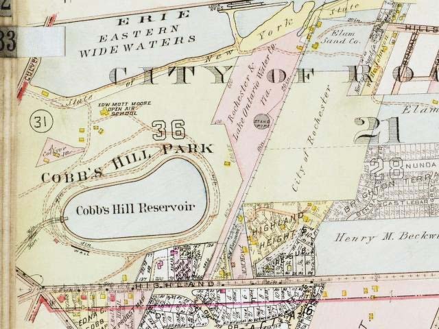
1918 Plat Map
In 1942 the Rochester City Council offered the use of space that had been used by the City Open Air School (for students with tuberculosis), and its surroundings at Cobbs Hill for the duration of the war for a cost of $1.00. “The army was granted permission to alter the existing structures provided that the setting would be restored at the end of the hostilities.” (Lehr, 1994, p. 5.) Barracks erected on the land initially hosted Italian prisoners of war brought to western New York to work on farms, and later German prisoners. After the war, the barracks were repurposed to house returning veterans. The barracks and surrounding barbed wire fences were later demolished. In 1957 the City of Rochester sold the 9.18-acre parcel of land to Senior Citizen Housing, Inc. with, among others, the condition that buildings on the property were to be for rental only to “aged persons” residing in the City of Rochester.
Local landmark designation in 1972 and 1974 encompass most or all the park other than this area removed from the park for Cobbs Hill Village.
Things to Know About or Notice:
Cobb’s Hill is part of a recessional moraine created by the Labrador ice sheet, a meandering ridge that continues West. In 1904 the hilltop beside what had been a quarry was purchased for use as a second city water reservoir, and that use continues to this day. In 1905 or 1908 (documents vary as to the date) George Eastman donated an additional 15 acres with the caveat that the City of Rochester acquire the adjoining Eastern Widewaters tract that had once been part of Erie Canal.
Today the park is widely used by residents from all over the city and surrounding areas. The track round the reservoir is particularly popular, as is the view of the city skyline from a point on the western edge of the hill. It is Cobbs spatially divided into many different use areas, including the elevated Cobbs Hill Reservoir area and the lower recreation and play fields located around the north and western base of Cobbs Hill.
Considered part of Cobbs Hill Park, but physically separated from it, is Washington Grove. A group of citizens purchased 26 acres of ecologically significant old growth oak hickory forest to prevent it being used as a gravel pit, and in 1912 transferred the land to the City of Rochester as dedicated parkland. In 1932 the grove, on the bicentennial of his birth, was dedicated to George Washington. It remains one of the few old-growth forest remnants within a city limits in the U.S.A. and in 2021 was given additional protections by the city of Rochester and inducted into the national Old-Growth Forest Network.
Changes
In 1950 the refectory on Cobb’s Hill designed by the Olmsted brothers was replaced by a police fire and radio building, to which a garage and enlarged parking area were added in 1965. In 2022, it was voted to renew and rebuild affordable housing near Lake Riley in the lower section of the Park.
Sources:
Bayer Associates, The Landmark Society of Western NY, Charles Birnbaum (2009). A Survey of Rochester’s Historic Parklands. City of Rochester.
Lehr, T. (1994). “Not in Our Back Yard,” in Rochester History vol. LVI, no 3. Summer 1994. Rochester, NY: Rochester Public Library.
Cobbs Hill Village Deed, signed 19th February, 1957.
